For 1800 miles Brandon has been hearing about the White Mountains of New Hampshire. Whether it be from other hikers, people in hostels, or others in town. They are hailed as the best part of the trail. Boasting over 35 miles of hiking above treeline, home to Mt Washington and the Presidential Mtn Range. The Whites are beautiful, but witnessing their beauty has to be earned. Hellacious climbs up Mt Moosilauke, down and up Gorham Notch and Pinkham Notch, the Whites are no joke. Good thing El Perro has had a warm up of over 1,000 miles to get ready. In the Whites there are "huts", in short, they are small camps with showers, electricity and food where tourists go to experience the Whites. Thru-hikers can stay at these fully staffed huts in a work for stay program, where a normal visitor pays around 80$ a person. Another plus in the huts is they have all you can eat soup if you hit them around lunch time, so plan accordingly. This can help lighten the 8 day venture through the Whites by not having to carry as much food.
Brandon will also be able to partake in the age old thru-hiker tradition of mooning the cog train that toutrists take up the mountain. El Perro revealed his plan to me, but I'll wait for him to show the pictures. Brandon is entering the greatest part of his journey, and also nearing the end. With around 440 miles left, a distance he has already covered 4 times over, he is on the short road. Brandon seemed evermore focused on the task though as I talked with him Monday night, the 8th of August. Southern Maine is difficult as well. The Bigelow Mountains offer tough climbs , slick rock and potentially nasty weather that he has avoided since the spring storms earlier in his trip. Mahoosouc notch is another land mark in southern Maine. It literally requires crawling on hands and knees to get through this one mile long area where an old glacier had carved out a path along a mountain of granite. It took me about an hour to travel one mile, a time frame that a normal thu-hiker can cover about 3 miles. It's a slow, yet fun experience! Best of luck to Brandon as he enjoys, in my opinion, the greatest part of the trail. He has definitely earned it.
Cheers,
Spencer
Wednesday, August 10, 2011
Tuesday, July 19, 2011
Fur Sure
I apologize for the long hiatus from blogging. But while we have all been marching away in the "Real World", Brandon has been continuing on the trail. Since the last blog post, El Perro has been digesting his half gallon of ice cream in one sitting by passing through all of Pennsylvania, New Jersey, and soon to be completed with New York. I was able to talk to El Perro this afternoon whilst driving home from work. He even claims to have passed through New Jersey faster than I did in 2007, so he must be moving pretty quick. However, hiking fast is a double edged sword. Sure, the more miles you cover in one day, the more accomplished you feel, while on the other hand, the more miles you make, the shorter your journey becomes. Certainly, on a trip like this, it is the journey that is more important than the destination.
There is not a day that goes by that I do not think about my thru-hike. What a simple way to live. No boss, telling you what to do, no traffic jams, no commercial breaks. Just living. One with your environment, not a product of it. For those who don't fully understand what it is like to do what Brandon is doing, go on just a week long trip. If you can't do that, go on a weekend trip. And if you can't even do that, go on a day hike. Try and see just how many miles you can go from sun up to sun down.
Hiking 2,175 miles may not seem like the most enjoyable thing to do for many. But its not just about doing it for the simple pleasure of hiking. It makes you appreciate everything else exponentially more. A thru hike is a moving experience, and I applaud El Perro at his performance thus far. Recently he has experienced tired feet and a sore neck (possibly from an awkward nights rest), two things that can hinder your attitude and physical ability greatly. Yet Brandon continues on. As Brandon climbs up and down mountains, so too can a hikers emotions. Separated from loved ones, friends and family alike, it is definitely not easy being out there. Though I believe he knows just how grand of a task he is partaking in.
As Brandon travels through the final miles of New York, he will continue rocky, roller coaster terrain into the New England states of Connecticut, Massachusetts, as the gradient kicks back above 4,000' for the first time since central Virginia. Vermont, New Hampshire and Maine are by far the most remote states and in turn, the most rewarding. It is an old trail saying that when you get to the Upper New England and NorthEast states, you have hiked 80% of the trail and only done 20% of the work. It is true, the terrain is more difficult and harder, but tougher still has been El Perro's preparation to get there.
Alast, Brandon has also joined the Bear Club. One upping many by actually catching it all on video. The phrase "Ain't got pictures, ain't got nothing" cannot apply here. Sunday afternoon El Perro sent me a video of two cubs darting across the trail just in front of him. A blood pumping encounter to be sure.
Warpzilla Out
Monday, July 4, 2011
Halfway! 1090.5 Miles to Go!

Brandon arrived at the AT half-way marker on Saturday, July 2nd. It is tradition that once a thru-hiker passes the half way point that they stop at the Pine Grove General Store (the nearest covenience store) to take part in the "half gallon challenge" --- eating a half gallon of ice cream in a single sitting. And of course, Brandon was up for the challenge! His flavor of choice was neopolitan. Out of curiosity, I googled Hershey's neopolitan ice cream to get the nutritional information. According to Hershey's web site, a 1/2 cup serving contains 150 calories and 9 grams of fat. With a half gallon containing 16 1/2 cup servings, that brings the amount that Brandon consumed to a whopping 2,400 calories and 144 grams of fat!!! He said it took him an hour and a half to finish, but finish he did and earned his wooden spoon momento for the accomplishment!
Brandon has been putting in some serious miles over the last two weeks (almost 400 to be exact!). Arriving in Harpers Ferry, VA on June 28th, he was able to meet up with Scrub, a hiking buddy he had met on the trail before coming home. Brandon was really glad to be reunited with a familiar friend and he and Scrub continued to rack up the mileage this past week arriving in Duncannon, PA earlier today. They were enjoying one of Brandon's favorite "in town" meals (pizza) when I spoke with him and were planning to take a shuttle into Harrisburg, PA to watch a fireworks show later this evening. He seems excited to finally be able to put in more miles each day, even though his feet are starting to hurt a little more. A thousand miles is a LONG way to walk --- and Brandon gets to do it all over again! Only 1090.5 miles left to go to Katahdin, MA!
Check out pictures from Pennsylvania and Brandon's Half Gallon Challenge!
A Note From Brandon's Sister, Mallory
 El Perro has put in some serious miles his first week back on the AT. Record-breaking 194.4 miles! Let's all take a moment and say, "WooHoo El Perro!! Way to go!!" He is definitely rocking those miles!
On Thursday, June 23rd a very tired and accomplished El Perro called me from Rockfish Gap Shelter. (Let me just say I was so happy to hear from him! That was the first time I had heard from him in a week!) We had the best 20 minute conversation! He talked about the weather . . . hot, humid, rainy . . . repeat. Mentioned he was a little sore, but not too bad. He met a couple of guys from Tennessee who started the AT back in May and were at the point El Perro was on June 17th! (Just goes to tell you how the ridiculous storms that El Perro had at the beginning postponed him.) Also, El Perro mentioned there wasn't a fight to get to the shelters at night . . . a lot of folks have dropped out and just couldn't hang with Mother Nature. Still think YOU could get out there? My hand is down! Haha! Kudos to those of you who have conquered the AT!!
El Perro crossed into West Viginia on June 28th. I believe he was super pumped (and relieved) that Virginia was behind him! Virginia holds the most miles on the AT . . . about 550 miles. For El Perro to have those miles (and state) behind him is a HUGE accomplishment! El Perro crossed the border into Pennsylvania on Friday. Be sure to check the "Actual Mileage" spreadsheet (link is located at the top right of his blog) to keep up with where he is. We try to keep it updated even when we don't get something posted on his blog. So, check back often to see how far he has gotten!
AT Numbers:
1.129.1 miles to go!
8 more states to conquer!
10 lbs. (how much El Perro's beard weighs! hahaha I'm kidding! But seriously . . . )
2 feet (the same two that have brought him from GA to where he is today!)
2.5 million footsteps left (well honestly, I think he's running with all those miles he's doing!)
The total elevation gain of hiking the entire AT is equivalent to climbing Mt. Everest 16 times. (ummmmm whoa!)
Animal count so far . . . 2 tom turkeys (fighting!), tons of birds of all kinds (too many to count), snakes (including a rattlesnake and the biggest black snake he's ever seen!), tons of butterflies, chipmunks, lizards, a red salamander, and zero bears (thank GOD!)
El Perro: We wish you beautiful weather, clear skies and two strong legs to carry you closer to your dream of completing the AT! So very proud of you and how you ROCK each mile! Cheering you on! TEAM PERRO! Praying for you each and every day. Get ready for Maine! Until then --- love and hugs from your big sis, Mallory and family!
Click here to enjoy El Perro's AT journey: Part 1!
Sunday, June 19, 2011
McAfee Knob

Brandon is on the trail . . . again! Taylor (his brother) and I dropped him off in Catawba, VA (700 miles north of Springer Mt., GA) on Friday, June 17th --- right where his girlfriend, Michelle, picked him up 3 weeks earlier on Friday, May 27th. We watched with awe and admiration as Brandon methodically prepared to head out on the trail --- checking his pack, adjusting straps and hiking poles, etc. I could just imagine him going through these purposeful and adept movements each and every morning for the last 700 miles. He looked as if he had the routine down to a science and could probably do it in his sleep!
3.7 miles northward, Brandon arrived at McAfee Knob the most photographed vista on the Appalachian Trail. McAfee Knob has an elevation of 1,740 feet and an almost 270 degree view of the Catawba Valley and North Mountain to the West, Tinker Cliffs to the North, and the Roanoke Valley to the East. The picture above is Brandon sitting on the edge!
Brandon seems to be doing well and is happy to be back out on the trail. The severe storms that plagued the first part of his trip are continuing to impede his daily mileage. He seemed disappointed today that he had to cut his hike short of the 20 miles he had hoped for and settle for 14. El Perro is itching to get some major miles under his belt and cross the VA border. We're all wishing you blue skies and safe travels!
A few pictures of Brandon heading out and from McAfee Knob.
Friday, June 17, 2011
Next Stop Maine.
So for those of y’all still checking in on me I’ll start with an apology for the lack of maintenance on the site over the last few weeks (you have my word this will never happen again). Fear not though loyal followers after two weeks of running water, air condition, cable television, and high gas prices I am packing up once more and hitting the trail. I returned home at the beginning of June for my younger brother’s high school graduation. Also while home to ensure that my hemorrhaging bank account would in fact see me to Maine I choose to work a little (thanks again to both my employers for allowing me to come and go so freely). I will be returning to Catawba, VA where I left off at the beginning of June and continuing North. Catawba is exactly 700 miles from the start of Springer Mountain, GA… so for those of you who are still counting that only leaves me with a mere 1,480 miles. While I was at home I enjoyed spending time with family and catching up with friends, but my feet have yet to stop itching to get back on the trail. To say that I’m excited to get back on the trail would be an understatement. In the upcoming weeks I’m looking forward to putting Virginia behind me and also hitting the unofficial half-way point at Harpers Ferry where the Appalachian Trail Conservancy (ATC) head quarters is located. With very little excitement to report on since I’ve been home for nearly half the month I decided to upload the rest of the pictures I had taken in between Hot Springs, NC and where I left the trail in VA. So again to all of you out there still checking in and keeping up I appreciate all the support and again I apologize for the brief neglect of the blog. Click the link below to see the pictures.
From The Trail Part-2 Hot Springs, NC - Catawba, VA
From The Trail Part-2 Hot Springs, NC - Catawba, VA
Enjoy the pictures and check back soon,
El Perro Out
Monday, May 23, 2011
Afternoon Break at Dismal Falls
Sunday afternoon Brandon and a new hiking buddy, Mike "MANKS" Long, could not resist the temptation of taking a break at beautiful Dismal Falls. Here's a video of them having fun! Brandon informed me later that he is determined to find a higher water fall to jump from! I, in turn, informed him that he didn't have to share that with me! Before you view the video, make sure you turn off the music on the web site.
Sunday, May 22, 2011
True Grit
El Perro Noche phoned me yesterday. Since I dropped him back on the AT outside Damascus, VA, a week ago, it rained everyday (insert Forrest Gump quote about rain). Until finally, yesterday, the rain shut off. Brandon was talking on the phone while hiking, no you don't get a ticket for that. It felt like I was on the trail myself. He was in great spirits. Rain on the trail is like a free shower. So think about that next time you find yourself running to your car from the store in a summer thunderstorm. As the weather heats up, rain becomes welcome. And its not like you just throw a jacket on in the rain while you're hiking up and down mountains, not on the Appalachian Trail. The heat your body generates will just soak your jacket from the inside in a rain storm. So, you just keep it in your pack, and will have something dry to put on when you get to camp.
You might be thinking, how in the world do you just deal with it raining for a week straight? Everything is wet, dirty and uncomfortable. You have to "embrace the beautality". Attitude is everything out there. You can be in the best shape of your life and still not be able to do it. But you can also be in the worst shape of your life and be able to do it. There is a lot to think about out there, but the great part is, you don't have to think about anything. Other than where will I sleep, where will I get water next, there's not a lot of big decisions you have to make every day. Well, unless the choice between should I eat a Little Debbie Cosmic Brownie or a Payday is a big choice. Worst case scenario, eat both, and you can't go wrong.
Brandon is heading towards Pearisburg, VA for his next resupply. A decent town, it does have a tough decent and ascent in and out of town. Hopefully the weather will hold out for a while so he can enjoy some of the great views that Virginia is home to. On his fourth state of the trail, the overall trail maintenance, and physical difficulty of the trail in Virginia is right at average. There are some difficult parts, but the hard climbs are more rewarding than any of the other states he has been through, (weather pending of course). By the time he gets to Pearisburg, VA he will have travelled 627 miles. The specific stretch of trail he is on will his longest stretch between resupply points thus far. He told me on the phone that he wants to complete the trail "now more than ever". Its just like anything else. The more time and devotion you put towards one single thing, the more you want to see it through. There is little that can stop him now.
Warpzilla Out
Monday, May 16, 2011
Pictures from the Trail
Okay so I have not done a better job of keeping eveyone updated on Brandon's progress as I said I would in my last post. Thank goodness for Spencer!
Brandon asked me to share some of the pictures he has taken on the trail. Combined with them are some photos Michelle took while she was hiking with Brandon that she was kind enough to send to me. There are some great shots of the two of them together along with picturesque mountain views, beautiful wildflowers, some occasional wildlife (no bears yet! thank goodness!), and other points along the trail that Brandon found interesting.
As you're enjoying the pictures be sure to notice the ones of all the fallen trees. As Spencer mentioned in his last post, Brandon has endured many storms passing through the area this spring. (I think I heard the weather man report that this spring the eastern US has seen the worst, tornado-ladened storms of the last 40 years!) Each day after one of these ferocious inconveniences from Mother Nature had passed through, Brandon would get out his camera and take pictures of all the "rearranging" she had done to the landscape. Thank goodness all the hikers have remained safe even though there have been some close mishaps with small measurements of distance between fallen trees and tents where they were bedded down for the night. We continue to keep them all in our prayers for a safe journey! I guess it is easy to sit here in the comfort of our home while a storm is raging and tell Brandon to be appreciative of the wonderful adventure he is on! That young man has more courage than I could have ever imagined and I am so proud of him!
Some of my favorite photos are the ones of Fontana Lake -- absolutely breath-taking! And of course I love all the mountian views! Who could ever get tired of looking at those?
Sunday, May 15, 2011
Damascus, VA and Trail Days

Brandon as he entered Damascus, VA on 5/12
My dad, Jim McKay, and I arrived in Damascus late Friday night to pick up Brandon and take him to a cabin we had rented for the weekend just a few miles out of town and away from the madness. With AT&T service lacking heavily in the area, we had arranged a general area where we would pick him up, but with so many people around we were not sure exactly how we would find him. After making one pass of the town block where we thought he might be, we were unable to locate him. Then, we went by for a second pass to find a bum-like figure sitting on the corner of the sidewalk. The glow of an iphone screen lit up the face of Brandon as he simultaneously recognized me hanging out of the window of the passenger side of the car. Brandon was borrowing some free wifi to try and communicate with the outside world.
He was in good spirits and happy to see us. We drove him by tent city to grab his things and we made our way to our cabin for the weekend. He filled us in on the wet past few days he had. With somewhat good success of dodging major storms on his trip thus far, earlier this week his luck ran a bit short. Camping at Vandeventer Shelter on Tuesday night, a dangerous storm rolled in from the North. The shelter, which sits right on a ridge overlooking Tennessee, has very little room for tents and with everyone trying to make it to Damascus for Trail Days it was very crowded. A shelter that typically sleeps about 6-8 people held about 15-20 that night as Brandon snagged the last spot in the shelter that night. An unfortunate characteristic of this shelter is that its orientation to the elements was poorly executed. The open side of the 3 sided structure faced the north, the direction the storm was coming from. According to Brandon the wind was blowing rain straight into the shelter all night. Even with a wall constructed of thru-hikers sleeping pads, the rain still reached the far wall of the shelter. The violent storm even blew down trees that landed between a few tents. Everyone was very fortunate to have no big injuries to their bodies or their gear.

Vandeventer Shelter: Photo From User SmokyMtn Hiker on Whiteblaze.net
Needless to say, Brandon was happy to get out the bad weather and the chaotic tent city. Saturday, we walked amongst the vendors of Trail Days and watched the thru-hiker parade where all the classes of thru-hikers old and current walk down main street whilst a bombardment of water balloons and super soakers are being thrown/sprayed at anyone and everyone. Having been a past thru-hiker, I thoroughly enjoyed the festivities. Because I started my hike in mid-May, I started after Trail Days had already happened and had not made it to Damascus to check it out until this weekend. We made sure Brandon was getting plenty of good food and anything else he might have needed.
I noticed this past week while emailing with Brandon to see where we were going to meet up in Damascus that he wrote El Perro Noche where someone would normally type their name at the end of an email. I curiously brought up the issue of not having a trail name yet shortly after we met him Friday night. When I met him in, GA a few weeks ago; he was telling me about how the little stuffed Dalmatian puppy he had been carrying, given to him by his sister, was making a good pillow on the chilly nights where he was wearing all of his clothes. Immediately I chuckled and chimed in, "Pillow Pup". Waterbug (Kevin) and Russ (now, Special Delivery) erupted in laughter, claiming that had to be Brandon's Trail Name. Brandon immediately refused to answer to that somewhat embarrassing name. Since that night in Hiawassee, Brandon has struggled to gain a different trail name. After talking with another hiker who heard the story about "pillow pup"; he suggested the name Night Dog. A much more masculine take on the name. Brandon was sold on that either though, thinking people would assume he was some kind of Harley Davidson Bike rider. Then, Brandon added a little hispanic twist to night dog, and so it was. Brandon is now, El Perro Noche; Perro or El Perro for short. Well done El Perro Noche.

It was an on and off rainy weekend with a big thunderstorm Saturday night. Thankfully, we were under the safety of the tin roof of our cabin as we fell asleep to that relaxing sound. After a big breakfast this morning, and one more shower, we finally got El Perro back to the trail right before lunch time. I'm very proud of El Perro, as everyone should be. He has faced some tough weather during this crazy Southeast Spring. Perro is now in his fourth state of the trail; and will be for a while, because Virginia is about 525 miles long, taking him near the unofficial halfway point in Haper's Ferry, WV. Virginia offers a much larger amount of good views and overall better trail conditions. He's looking forward to the bittersweet town of Daleville, VA where he plans to take advantage of the last Bojangles' he will have access to while on the trail. Before that he will have a beautiful stretch in the Grayson Highlands area of Southern Virginia (home to a large population of wild horses), breathtaking Mcafee Knob, Tinker Cliffs, and the challenging Dragons Tooth. With a hard hike ahead of him over the next couple of days, climbing up to Mt. Rogers, El Perro Noche ascended from the road leaving Damascus and into the woods right about lunch time today.
Tuesday, May 10, 2011
Thursday, May 5, 2011
Making Miles
Brandon and Michelle atop Charlie's Bunion in the Smokey Mountains
Whatever the reason; better yet, combination of reasons, there's no denying that Brandon is doing well.

I talked with our hiker today, as he was resting and resupplying in Irwin, Tennessee. He reported a chilly night last night, with temperatures dipping down into the mid to low twenties. That, combined with getting a little wet the night before and during the day, he didn't get the best nights sleep he's ever had. It won't be too long before he's wishing the cold back as things heat up for summer. At least he's got a little bit of natural insulation left, although its quickly diminishing. Knocking out twenty to twenty-five mile days is an incredible workout. And there's no doubt that he's burning more calories than he's taking in. The thru-hiker diet plan blows the atkins, south beach, caveman and any other diet plan out of the water. It's the eat whatever you want, and still burn more calories than you could possibly take in plan. Oh, and by the way, you also get to walk from Georgia to Maine. Pretty awesome.
Panoramic View atop Max's Patch
On the phone with Brandon, I got a few "I told you so's" in. For example, Brandon was initially carrying some sandals for after hiking while he was at camp called chaco's. Although very comfortable, they weigh in at a whopping 2lbs. Brandon has since switched to a pair of Croc like shoes called Waldies, weighing just 12oz. You can tell a thru-hiker anything, but until they actually get out there and experience it, some things you just have to learn for yourself. This begins to fall under the principle rule of thru-hiking. H.Y.O.H. Standing for "Hike Your Own Hike". Anybody can question what you do, or why you do something. But no one is going to tell you you're doing something wrong. People will put in their two cents, and you can do with it what you want. In a media driven world, with so many opinions flying around, everybody wanting you to believe in a certain thing; what a nice lifestyle change. Then again, that's just my two cents.
Brandon is planning on being in Damascus, VA next week. The weekend of the 14th is a huge thru-hiker festival in Damascus called Trail Days. This is where all the hikers get together in the "friendliest town on the trail", Damascus. Damascus, VA is approximately a quarter of the way to Maine. Every year, the entire town revolves around this festival for the weekend. If you have never been to Damascus, it is a great place to visit. Take the entire family. You can hike part of the AT or take a 17 mile downhill bike ride down the Virginia Creeper Trail (an old railroad bed). The two actually overlap for a few miles. Reaching nearly the quarter complete mark, its hard to believe. However, the next section is over 500 miles, all in the state of Virginia. As Brandon becomes more comfortable with the physical aspect of the challenge, the mental challenge will begin to set in. I believe Brandon has the right attitude and skill set to overcome whatever he may encounter. Afterall, he's just walking, right?
All for now,
Spencer "Warpzilla" McKay
Tuesday, April 26, 2011
Still Heading North . . .
Yes, Brandon is still hiking! While he has been busy scaling mountains --- "an outdoor landmass, higher than a hill" variety --- I have been busy wading through mountains --- "a vast number or quantity" of preparations for Holy Week and Easter worship services. Whew!! Maybe things will slow down a little now and I will have time to keep you all more updated on Brandon's progress.

AT was a gift from Brandon's sister, Mallory, her husband Curtis, and son Bohde. She tucked him away in a box full of other goodies they presented to Brandon before he left Kannapolis in the hopes that some of the items would provide a laugh and maybe even prove to be useful in some way on the trail. The word is from Brandon that AT has turned out to be a pretty good pillow!

Brandon loved the Nanatahala Outdoor Center and said it was a great place to spend the night. Upon arriving there he picked up his second maildrop from home. He called me while sitting beside the Nanatahala River, with his feet propped up, enjoying some much anticipated refreshments and I could hear the sound of the river through the phone. What a life! I would love to be there!
After spending the night at the N.O.C., Brandon, Russ and Kevin took it easy on the morning of April 21st, enjoying the area for a while before heading out for a shorter hike of 6.9 miles to Sassafras Gap Shelter. Just before reaching the shelter, Brandon sent me this picture from the summit of Swim Bald (elevation 4750').
 From Sassafras Gap Shelter, the trail northward led them on a 15.2 mile trek for a night's rest at Cable Gap Shelter. The next day's 6.6 mile hike brought them to Fontana Dam Shelter. From listening to Brandon speak of these few days it sounded like the guys had really settled into a nice routine of hiking, taking lots of pictures, and just generally enjoying their surroundings and each other's company. He said the days were fun and he was filled with a wonderful sense of accomplishment when they would sit down in the evenings, look over their maps and talk about how many miles they had travelled that day.
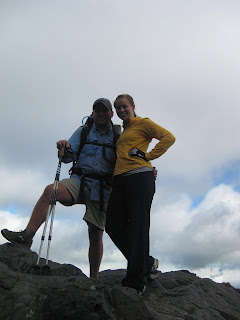
Michelle met Brandon in Fontana Village on Sunday evening and the two of them headed out on the trail yesterday morning. To say that he was giddy with excitement at having Michelle join him for a few days would be a slight understatement! They arrived at Spence Field Shelter in the evening --- a 17.4 mile hike. Way to go Michelle!
They are looking forward in the next couple of days to rejoining Kevin and Russ, enjoying the view from Clingmans Dome, and having lunch in Gatlinburg, TN. Happy Trails you guys!!
Wednesday, April 20, 2011
Nantahala Outdoor Center
Brandon is off and running. Well, not running, but darn close. The past few days mileage has cranked up significantly compared to last week. Hovering right under 20 miles for past two days, Brandon, Russ and Kevin have made some serious progress. The section of trail from Hiawassee, GA to N.O.C. is not an easy one either.

View Atop Wayah Bald
On the last post, Brandon stood atop Albert Mountain, a significant, tough climb with a rewarding view from atop a fire tower at the summit. I don't know who wrote the guidebook for the Southern States of the AT, but every time a "scenic overlook" is marked, it makes you wonder what time of year the author wrote it. It must have been written in winter time, otherwise, each mountain top is as green as the valley below it. This ongoing string of many unrewarding mountain top views is commonly referred to as the green tunnel. The green tunnel syndrome disappoints a lot of hikers, but I feel it makes the views you do get more rewarding.
After knocking out a four day stint to the Nantahala Outdoor Center, near Bryson City, NC, Brandon enjoyed half a day of relaxation at the River's End Restaurant, which hangs over the Nantahala River. This little tourist town, based around whitewater and paddling sports, is nestled in a valley between the ridge that the AT runs. It is a long six mile decent down into it, with a challenging ascent out of town as you make your way to Fontana Dam, the Southern Terminus of Smokey Mountain National Park. Brandon is planning on arriving there soon, before slowing things down and really enjoying the Smokey Mountains, weather pending of course.

View South of Clingman's Dome
Things to look forward to over the rest of the week and weekend include climbing up to Clingman's Dome, the highest point on the Appalachian Trail (it's all downhill from there), the Smokey Mountains (America's most visited National Park), and reaching the 200 mile mark (just under 2,000 miles to go; it doesn't sound so great when you put it like that) and a host of other views and potential wildlife sightings.
Monday, April 18, 2011
Sweet Home Carolina
After spending Saturday doing what Brandon does best --- kicking back and socializing --- he set out northbound on the trail around 10 o'clock Sunday morning. 16.5 miles later they (Brandon, Kevin & Russ) arrived at Standing Indian Shelter, the second shelter after crossing the Georgia-North Carolina border. I think the day of rest re-energized them so much that they decided they were not finished for the day when they arrived at Muskrat Creek Shelter and pressed on for an additional 5 miles. I'm sure the fact that Spencer showed up and assisted Brandon in lightening his pack by a good 8 pounds helped to quicken his steps up the trail tremendously! Thank you Spencer! After hiking 14 miles today (about 3 pm), Brandon sent me a video from the top of the fire tower at Albert Mountain.
Great view Brandon!! Thanks for sharing it with us. Looks like you have settled into a great pace!!
Great view Brandon!! Thanks for sharing it with us. Looks like you have settled into a great pace!!
Saturday, April 16, 2011
Georgia's Off My Mind
Come tomorrow, I will complete the first state of the trail, Georgia. I look forward to crossing into my home state of NC, where the sweet tea is sweeter, the women are prettier, and hopefully, where the sunshine is more plentiful. It's been a roller coaster of weather thus far. After battling combinations of sleet, rain, and fog; warmer and sunnier days would be welcomed at Mother Nature's earliest convenience.
The trail has had its own ups and downs as well; literally, lots of hiking up, and then right back down. Commonly referred to as PUDs (Pointless Ups and Downs). Because the Appalachian Mountains are so old and have been eroding for millions of years before the Himalayas and even the Rocky Mountains, the tops of what were once giant peaks are now much closer together. This act of nature has become the vain of my existence as I slug up and back down each climb. As I begin hammering away the miles, 67.5 so far, I feel as though my trail legs are getting under me.
I have been meeting lots of people and the desire to get miles under their belts is all the talk on the trail. Russ, Weather Bug (Kevin, mentioned in an earlier post) and a host of others are here with me in Hiawassee, GA on my first town stop on trail. With gnarly weather rolling in on Friday night, we all decided to get into town and hunker down in a motel while the storm plowed through the mountains. The same storm system wreaked havoc on the piedmont of NC and much of the Eastern United States today. Spencer, aka Warpzilla, travelled from Raleigh to spend the weekend with me as well, Spreading Trail Magic* like its his job. He arrived Friday evening during the storm just in time to drive us to the local Mexican Restaurant, Monte Alban.. Not because we were craving Mexican necessarily, but because the rest of the town had shut down at 9:00 PM. Here we enjoyed chips and salsa, burritos of thru-hiker proportions, and eavesdropping of how the local high school baseball team (who was sitting beside us) had gotten in to what sounded like an epic fight with a rival team.
As we took things back to the motel, we continued trail talk and finally went to bed... in real beds. They were not quite Hampton Inn posturepedic grade mattresses, but they did the trick. Tonight we are bunking up at the Hiawassee Inn, because Mull's Inn, where we stayed last night, had rooms reserved. More thru-hikers showed up today as well. Spencer and I gave a few of them a much welcomed ride to town. Hikers we met today were not quite as lucky as I because they had to brave the storm last night. I reckon that I too will have to endure a few storms during this adventure, but I'm not sure if I'd like them sooner rather than later.
The next resupply will be at Nantahala Outdoor Center (NOC) near Bryson City, NC. I plan to be there in four days, give or take, mostly give. According to the weather forecast, midweek this coming week has a good chance of precipitation and temperatures dropping off on Tuesday. You'd think knowing the weather would be an advantage, but truth be told, it doesn't really matter. Weather or not, pun intended, the trail heads north, therefore, so do I.
Warpzilla helped me shave a few ounces today as he made me layout all the items in my pack in the motel room. I even exchanged my stove for one he gave me, which burns denatured alcohol. It is made of a metal bottle and weighs no more than 2 oz!! Alcohol burning stoves are all the rage on the trail. One can even be made out of a cat food can, which Warpzilla has shown in a youtube video. With just a couple ounces of denatured alcohol fuel, I can boil water for dinner every night.
I am really beginning to enjoy this journey. As my nerves begin to settle a bit more, and I begin reaching significant milestones; like completing my first state and reaching 100 miles, I feel my confidence growing. Knowing that tons of people are following the blog and reading about my trip gives me comfort as well. All the support is greatly appreciated.
Until Next Time,
B. Moore Out
Friday, April 15, 2011
Day 6 - Hiking in the Clouds!
Brandon is now in Hiawassee, GA! He and his new hiking buddy that he met at the shelter last night, departed from camp at 8 o'clock this morning and arrived at Dick's Gap at 12:15 pm. Tray Mountain Shelter is located at an elevation of 4200 feet. The 11-mile trail that descends down to Dick's Gap stays around 3800 to 4200 feet for much of the way. At that elevation, Brandon said it was like they were hiking in the clouds. The weather was foggy, rainy and dark, but as soon as they started descending, he said the weather cleared up and everything became lush and green. His plans are to stay at Mull's Motel tonight, take a "0 day" tomorrow and just hang out. The severe storms that we are supposed to have tonight and tomorrow are expected to pass through the area where Brandon is also. I'm so glad he was able to get to town before the storms move in and looks like things worked out great with the bad weather coinciding with his day of rest. He sounded excited that there was a Food City, Family Dollar, Hardee's and a $6.00 "all you can eat" buffet all within walking distance! He will head out on Sunday morning for Muskrat Creek Shelter, the first shelter on the AT in North Carolina. The trail leading to this shelter begins at an elevation of 2600 feet and climbs to an elevation of 4600 feet. With that said . . . rest well and eat hearty, Brandon . . . and get ready to climb!!
Thursday, April 14, 2011
Day 5 - Approaching North Carolina!
After heading out this morning from Poplar Stamp Gap, Brandon stopped for lunch and to refill his water at Blue Mountain. He hiked 12 to 13 miles today arriving at Tray Mountain Shelter, his stop for the night, right before 5 o'clock this evening. While Brandon continues to meet new friends along the way, I think he is really missing his friends at home. He hopes to arrive in Hiawassee, GA tomorrow with tentative plans to take a "0 day" on Saturday for some much deserved rest. Brandon is really looking forward to crossing the GA/NC border. I think he continues to let the enormity of the trip overwhelm him at times and that he will feel a great sense of accomplishment when he arrives in North Carolina. Brandon - Keep in mind the miles you've traveled and not the ones ahead of you! And just remember, any time you want to come home and go to work for me I will trade places with you in a minute!
Wednesday, April 13, 2011
Day 4 - Poplar Stamp Gap

Brandon has completed day 4 and if my calculations are correct (Spencer please correct me if I'm wrong) I think he has hiked around 42.5 miles since leaving Springer Mountain around 2 pm on Sunday afternoon.
Unfortunately, the clouds in the picture I posted on Tuesday morning did not clear and Brandon said he hiked all day in the rain. In spite of the weather, he seemed to thoroughly enjoy the trek up Blood Mountain, the highest peak on the Georgia section of the A.T. with an elevation of 4,461 feet. The view from the top of Blood Mountain is alleged to be spectacular, but Brandon said it was so foggy he was not able to get very good pictures. As they approached the summit he said the wind was blowing very hard and the rain changed to sleet. He made sure to mention to me that his "capilene kept him toasty warm."
Brandon pulled in to Neel's Gap around 3 pm yesterday. I think the pizza and root beer Spencer posted a picture of was a welcome meal after all the ramen noodles! Of course, Brandon LOVES ramen noodles and has been known to eat them every day for several days in a row sometimes.
He said this morning started off bright and chilly (the temperature was around 39 degrees last night) but that the day warmed up fast. He hiked yesterday and today with a guy we met on Sunday. We hiked up to the top of Springer Mountain with Brandon before we left and as we were sitting there taking pictures another solo hiker arrived. Talk about divine intervention! I think that was an answer to a mother's prayer. The two of them immediately struck up a conversation and I think Brandon has enjoyed the "on and off" company of his new friend. He was originally from New York, but has been living in San Diego for the last several years. Like so many during this difficult time in the economy, he has been out of work for a while and decided to attempt the hike. Brandon also met a father and son from Florida. I believe that Spencer is right -- there is a different kind of bond that forms with folks that are out there facing the same challenges.
Brandon is spending tonight at a camp site at Poplar Stamp Gap. He said it is about 1 mile past Low Gap Shelter. If all goes well he hopes to arrive at Hiawassee in 2 more days.
Keep taking it one day at a time, Brandon. Know that we have you in our thoughts every minute of every day. Anything is within walking distance if you've got the time and you've got plenty of time.
Tuesday, April 12, 2011
Walasi-Yi Mountain Crossing aka Neel's Gap
While grinding away at work during another 12 hour day on the construction site, I got a call on my phone. "Brandon Moore", the caller ID showed. Brandon had made the decent from Blood Mountain to the Walasi-Yi Mountain Crossing. Blood Mountain is one of the first true tests of physical ability on the trail; although there is a lot of up and down between there and Springer. Neel's Gap consists of a small road crossing and a little general store with such amenities as a snack bar, supplies, bunk room, laundry, and more importantly,showers.

Photo: A well earned snack at Neel's Gap
The General Store here is infamous as the first place hikers get a chance to send home all the things they have figured out that they don't need in the first 2-4 days of hiking. Brandon said he faired pretty well as far as things he sent home was concerned. Due to the fact you have to carry everything, its easy to part with most things. "Ultra-lite hiking is contagious" he told me, as I am already aware. He even split up his 3-pack of moleskin to just 2 sheets and threw the wrapping away. Better yet, Brandon rationed out his ibuprofen for the next three days, and mailed the rest to his next resupply. I think it is safe to say that Brandon has the hiking bug, it's contagious folks.
Brandon was in good spirits, and perhaps a little intimidated by the enormity of the journey he has undertaken. Covering just over 30 miles in three days is a great start. I told him not to even begin worrying about how far the finish is. If the object is to get from Georgia to Maine the fastest, then there are certainly more efficient means to achieve that. It sounded like Brandon had met a few people on the trail and was planning on hiking with them the next few days to Hiawassee, GA. With so many people starting the trail this time of year, its not uncommon for people to join up and plan/hike together.
Everyone on the AT shares a common goal, to walk from Georgia to Maine. Because pretty much everyone you meet is "in the same boat", people bond together easier. A frequent explanation of friendships on the trail is that a day spent together on the trail is like a month in the "real world". This is most likely due to the variety of situations the trail puts you through; an ongoing physical and mental challenge.
View from first climb of the day!
 Boy, am I jealous! I'm sitting here at work at my computer while Brandon is looking at that view!! Wish I was there!! Brandon is hoping to make Neels Gap today or tomorrow. Most of the folks he has been hiking along with are taking a "0 day" today. They had severe storms last night and hopefully all these clouds will be moving on out as the day passes. The weather is supposed to be cooler for the next few days which should make for easier hiking. (You can click on the picture above to open a larger version of this gorgeous view!)
Monday, April 11, 2011
Heading North!


After months of researching, planning and preparing, Brandon set out from the top of Springer Mountain yesterday to make his dream of hiking the AT become a reality. We all think and talk about things we would like to accomplish, but having the courage and the discipline to make the necessary sacrifices to attain these achievements are, most of the time, just a little too difficult or take us too far out of our comfort zone for these feats to ever actually materialize. I admire Brandon so much for his audacity and determination and his Dad and I are more proud of him than words can say! OKAY NOW, enough of the motherly chatter---I better cease and desist before Brandon revokes my blogging privileges!
During the car ride to Gainsville Saturday, Brandon was telling us about how touched and humbled he was by all his friends that showed up on Friday night to offer him their well wishes. His Dad and I are so grateful to know that he has such a wonderful support group and we wish to express our thanks to all of you! I hope that you will all continue to keep him in your thoughts and prayers in the days ahead.
When the time came to say goodbye and his Dad, his brother, Taylor, and I were preparing to get back in the car and leave, we were running through the last minute check list (as moms and dads have to do!) Brandon was very patient with us and answered "yes, I have it." and "yes, I'm good." He finally said, (with his usual Brandon humor) "I have everything, now all I need to do is go walk a couple of thousand miles." We all laughed, hugged him long and hard, shed a few tears and watched him leave until we could no longer see him through the trees. I know in my heart that he will be fine. He has a great head on his shoulders and I have all the confidence in the world in him that he will meet each challenge that comes his way and persevere. (Okay, so did you think I would really stop with the motherly chatter?! Not a chance!)
Wishing you Godspeed, blue skies and safe travels dear son! You're in our hearts and even though the distance between us grows with each passing day, we're never more than a phone call away.
Sunday, April 10, 2011
Follow Brandon on Google Earth
Can't stop checking the blog wondering where Brandon is? Track his progress with Google Earth.

Step One: Download Google Earth (Free): Here
Step Two: Download A.T. GIS Centerline data: Here
Step Three: Download A.T. GIS Shelter Data: Here
Step Four: Open Google Earth and install.
Step Five: Once Google Earth is running go to File>Open and load the .kml files (A.T. centerline and A.T. GIS Shelter data.)
Step Six: The Appalachian Trail will be loaded in Google Earth and each shelter should also be marked. If you open Brandon's link to his itinerary at the top right of the blog, you can find the locations where he intends to be each night.
If you are having trouble figuring it out, post a comment.
Screenshot from Google Earth
Saturday, April 9, 2011
Ready, Set, GO...
Hello My FOLLOWERS,
Well it's finally that time. The day has come and I'm past the point of no return. The family and I just checked into the hotel in Gainesville, GA which is about an hour and a half away from where the A.T. officially starts at Springer Mountain. The Game plan for tomorrow morning is to wake up and have a big ole' southern style breakfast make the drive to Springer and try to be on the trail by no later 1 o'clock.
I want to say thanks to everyone who has helped me plan and prepare for the big trip. Having the support from my family and friends has made it very easy to commit and plan for such a long adventure. A thanks is in order to both of my employers who have agreed to let me take a leave of absence and return to work immediately. A special thanks to Spencer McKay who has gone above and beyond in helping me plan and prepare... if there is anyone out there who has a interest in ever hiking any part of the A.T be that a thru-hike or just a section your first contact should be Spencer. His knowledge and passion for the trail has put me at an excellent starting point. Thanks to all of my friends who put together care packages and gave me all sorts of goodies before I left. I promise I will enjoy every cookie or candy bar I eat over the next few months. And last but not least thanks to my family. I no it cannot be easy for my parents to watch me walk away into the woods alone, but their support and excitement for me has surpassed anything I could have hoped for when I first told them my plans to hike.
Now that thanks have been delivered I would like to take a quick minute to point out some newly added features to the blog. Thanks to Spencer we now have streaming music for your viewing pleasures. I have added a list of all the gear I will be carrying as well as my itinerary for the first 1,000 miles of my trip. In the gear list you can click an each piece of gear and it will take you to an external link where you can view each individual piece.
The reality is stating to set in and I'm eagerly awaiting tomorrow. I hope y'all will check in often and enjoy reading about my trip.
I will try to post an update when I arrive at Neels Gap.
Until next time enjoy indoor plumbing.
-B.Moore
NOTE: IF YOU DO NOT LIKE THE MUSIC THAT IS PLAYING WHEN YOU ARE VIEWING MY BLOG HIT THE MUTE BUTTON.
Thursday, April 7, 2011
No Rain, No Pain, No Maine
Dear Blog Followers,
I cannot begin to describe how jealous I am of Brandon's (quickly) upcoming adventure. My name is Spencer McKay aka "Warpzilla" and I hiked the AT in 2007 in honor of a fellow Eagle Scout. Brandon and I went to UNC-Charlotte together and I have been helping him plan and prepare (mentally and physically) as best I could. The Appalachian Trail has a very special place in my heart. I wish everyone had the ambition and desire to even attempt such an undertaking.
Brandon and I traveled down to Springer Mountain, Georgia, the Southern Terminus (Brandon's starting point) of the Appalachian Trail a couple of weeks ago to do a mock start of his journey. The thought was to get him prepared and familiar with his surroundings so that when his start day did come, he would be better prepared than you're average joe. I was very impressed with how Brandon was prepared for his journey. How his pack was packed. The gear that he had. Most importantly though, his attitude. According to the Appalchian Trail Conservancy's website. About 10% quit the trail within just the first 20 miles or 1% of the entire trail. About 50% make it halfway, Harpers Ferry, WV. While just under 30% of all hikers who set out to thru-hike the Appalachian Trail complete it, on average.
I've met a lot of people that say they want to hike the AT someday, and maybe they will. But actually committing to it, and getting out there, is an entirely different story. Granted, some people may be in a more difficult time in their lives to devote 4-6 months of their lives to one specific thing. Especially when that thing means leaving a mortgage, family, and other "real world" obligations on hold for that period of time. There is no better time than now for Brandon to begin this hike. He's fulfilled his educational duties academically, but I think his education of life awaits him on the trail.
The trail teaches one all kinds of lessons. Most importantly, who you are. There is such a wide variety of emotions and situations that you can encounter within just one day of the trail then one could receive in a lifetime. Whether that be changing weather, physical ability, terrain, and an array of other unforeseen conditions. The trail humbles you, and in a good way. It can make you feel like an ant one minute and the tallest man on earth the next.
Perhaps Henry David Thoreau said it best;
"It were as well to be educated in the shadow of a mountain as in more classical shade. Some will remember, no doubt, not only that they went to college, but that they went to the mountain."
My best wishes to Brandon and his soon to be, journey of a lifetime.
Sincerely,
Spencer aka Warpzilla
Sunday, March 13, 2011
A walk in the park...
As most of you know by now I’m planning on attempting a thru-hike of the Appalachian Trail this spring/summer. I have taken a leave of absence from my job and set my start date for April 10th and as of right now I don’t think that will change (my parents are kicking me out of their house on April 9th). So since I will be on the trail for 4+ months I have decided to try and keep a blog to the best of my ability so that friends and family back home can follow my progress as I slowly make my way north.
For those of you who do not know what the Appalachian Trail is I have posted a picture of the trail in its entirety to the left and for a detailed description see the link that follows:
I will try to update the blog weekly as I come into towns for re-supply and rest. I will write to the best of my ability to describe life on the trail while hitting all the high points and entertaining mishaps of the trip. I hope many of you will follow my trip and I will try to be as detailed as possible in hopes that it will make for a more entertaining read.
Until next time…
B.Moore out
NOTE: IF ATTACKED BY BEAR POST WILL CEASE IMMEDIATELY…
Subscribe to:
Posts (Atom)